


HAI PHONG DEPARTMENT OF PLANNING AND INVESTMENT
HAI PHONG DEPARTMENT OF PLANNING AND INVESTMENT
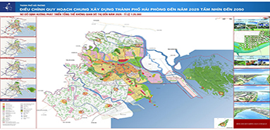
Hai Phong has about 600 streets, located in 7 districts. The urban road network covers a total of 324 km, the center is the Haiphong port area in the Cam River and extended to East, West and South. The longest road is Pham Van Dong street, 14.5 km long, starting from Rao bridge and ending at the beginning of the road to the tourist area of Do Son. The shortest is Doi Can street, connecting Le Loi street to Luong Van Can street in Ngo Quyen district, only 70 meters long. The streets in Hai Phong are very clean, narrow, but very rare congestion…

(Figure 5. Map of urban transport system)
In the field of construction and development of technical infrastructure, Haiphong urban area is expanding at a relatively fast speed. There are new urban areas in 5 districts, 6 satellite towns, in the Northern areas of the Cam River, in the North-West, South-East, on Nga Nam – Cat Bi Airport and Pham Van Dong roads. The speed of renovation and development of housing is accelerated, average area of urban housing reached nearly 8m2/person. The quality of life and living conditions of the people have been improved. The system of social infrastructure meets the requirements of living, creating a strong promotion of culture, tourism and services. The city attaches great importance to investment in the construction of urban technical infrastructures, especially the traffic systems such as National Road No.5, National Road No.10, Nga Nam – Cat Bi airport, Cau Rao – Do Son road, crossing Dinh Vu – Cat Ba island road, 100m road, Dinh Vu bridge and port, Lach Huyen gateway port, Tan Vu – Lach Huyen sea bridge, bridge overpass and a series of urban upgrading and development projects.
Source: Haiphong Department of Transport